In this post I will examine what aspects make a good or a bad map. I have a few examples and will start off by looking at the bad map....
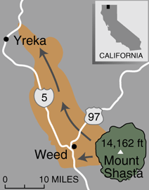
For some reason I cannot insert the picture itself but the map is poorly constructed. It has no title so right away there is no clue as to what it is trying to show. It is obviously of the Mount Shasta area, but has a strange color scheme going on, but no legend to tell the reader what it is showing. It shows two major roads, but again, unless you are familiar with the area you would have no idea. The map has two towns labeled, but no point to represent where they are so it is vague. The balance, placement and color of everything seems alright, but with no legend, it all has no meaning. The "bad map" also has some random arrows, again that have no meaning. There is no north arrow, and there is a scale. The problem with the scale though is that it has no numbers on it so therefore it is useless. This map did not have to be so poorly done. If the missing or poorly done aspects were corrected this might be an OK map. The bottom line is that now, in this context it is meaningless. It resembles little more than a map one might draw on a napkin in a restaurant. (http://pubs.usgs.gov/fs/fs002-97/images/Shastamap.gif)
The next map I would like to offer in comparison is a good, or better map showing recent earthquakes in California and Nevada. This is clearly what this map is showing because it is clearly stated in the title along with the contributing institutions. There is a scale and a legend and the colors used are easy to view and distinguish from one and other. The only problem I can really pick at here is the fact that the map contains earthquakes from the last hour, day, and week and there are some places where you cannot totally distinguish a point. It may be beneficial for this data to have a map for each one of these data sets. The size of the symbol for each earthquake shows approximate magnitude which is also distinguished in the legend. Perhaps the best aspect of this map is the fact that if you connect to it via the Internet, it is interactive. Not highly interactive but it does allow the user to select a point and it will zoom in and give you any additional/available information about the quake. If nothing else it zooms in and shows nearby towns and roads so one can get a better sense of where these quakes are. It is not the best map or the most intricate but it conveys its information in a cohesive way and is updated daily so its information is always current. ( http://pasadena.wr.usgs.gov/recenteqs/)
No comments:
Post a Comment