Sunday, May 6, 2007
Collaborative Cartography
Collaboration is always a powerful tool no matter what you are doing so long as its done correctly. Working together with a large group offers all different kinds of insight and feedback on projects. I don't know if its the same thing but at least the same concept has been our peer review sessions. Something that looks OK to you might in reality may not be working at all. It might hurt the pride a little bit but knowing what others think is pivotal in producing quality products. Not just the negative feedback either. Positive feed back lets us know what we are good at and it makes you feel good. Another aspect of collaborative cartography is that it makes large scale products seem possible. I mean take for instance the production of a work like an atlas. This task would be nearly impossible for a single person to complete, at least under any kind of set time frame. I Could actually imagine how an atlas could be ones life work like the one we often look at in class of Oregon. Its huge and contains so much data and text that for one person to make would be quite extensive. I still like creating my own work and being held accountable. Having your name on something that was difficult to create but tuned out excellent is a great feeling. On many occasions I have produced maps and been quite proud of myself. This is really no different from the pride you feel doing something independently. I guess my main point here about collaborative cartography work is that it still remains important to do your own work that you base on your skills and some of the feedback or ideas you receive from partners.
Mapping Nevada

This is one of my main disappointments in my cartographic path. Nevada is virtually all that I have mapped. From demographics to physical features to events. If it has to do with Nevada I have probably at least been exposed to it. The good thing about being so focused on this state with my cartography is that I have really come to appreciate this spot much more than before. In the past I thought of Nevada as a sparsely populated and vast desert that was both contaminated and boring. Of course after living here and going to school for 3.5 years I know better. I actually like this state which is a huge change for me. Growing up all we did was make fun of this state. I have mapped out population, crime, race and many other things pertinent to the state. I have even done some mapping of the geology of the area which was particular challenging first and foremost because I am not a geologist and second because the geology in this state is so very complex. Although it was to be yet another Nevada project I was looking forward to the atlas we had discussed building last year. The project never materialized, most likely because of a lack of funding but it would have been very cool and I know there are plenty of mapping opportunities for this state. I guess the bottom line is that no matter what region, area or state you are focusing on there will always be plenty of cartographic opportunity.
 the atlas we had discussed building last year. The project never materialized, most likely because of a lack of funding but it would have been very cool and I know there are plenty of mapping opportunities for this state. I guess the bottom line is that no matter what region, area or state you are focusing on there will always be plenty of cartographic opportunity.
old map new map

This seems fairly obvious, but I will delve into it a little bit anyway. In the old days maps were drawn based on observation and fieldwork. It is my opinion that we are moving way past that point. Old cartography, and I mean the really old stuff, though somewhat accurate are nothing in comparison to reality. as time went on and surveying techniques improved so did the maps being made and their accuracy. I think now though most of these maps are just relics. Cool pieces of art to hang on the wall, admire, and contemplate our roots. Otherwise in our times f technology, they are quite useless. We are now accurate beyond what any explorer could have imagined. The downside to this is that we miss out on that fieldwork. The excitement of being the first to see something. The first to study an area. That is all gone and we rarely will make it into the field except maybe to collect some GPS points. Most of the data we use has already been collected and now it is our job to find that stuff. I guess one could make the argument that now we cartographers have become a different type of explorer. We are data management pioneers. We will never draw a map by hand instead we will utilize the new technological avenues and it is our job to be excited about that and use it in a way that will be beneficial for.....whoever. Cartography is not the same nor will it ever be. This is the age of technology.
Virtual Worlds

When I hear this topic it reminds me of video games. Something, a world if you will or a space that lets a user virtually manipulate it in a variety of ways. From just simple exploration or actually solving a problem or reaching a goal. I also think of 3D cartography. Yesterday I was working in the cartography lab and another couple of student were creating a virtual world. They were actually creating a virtual downtown reno. The process they explained was long and laborious and the technology is fairly new so the entire thing is a learning experience. The fact is that it can be done and the results are fairly impressive. I mean what they were coming up with looked just like a miniature reno, nevada. I was impresses especially since pat  g had just demonstrated a little bit of this process in a recent class. I guess the bottom line is that this is a new cutting edge type of cartography that in a lot of ways can be much more interesting way of looking at places cartographically opposed to that of paper or standard type maps. Although I don't think that regular maps will ever go completely out of style I do believe in new ways of doing or looking at things. Another example I thought I would ad is that of virtual tours like those that are now often offered online for things such as homes for sale. They give potential buyers a walk through a home without them ever leaving their computer. This means less wasted time going to visit places they have already decide are not right for their needs.
 g had just demonstrated a little bit of this process in a recent class. I guess the bottom line is that this is a new cutting edge type of cartography that in a lot of ways can be much more interesting way of looking at places cartographically opposed to that of paper or standard type maps. Although I don't think that regular maps will ever go completely out of style I do believe in new ways of doing or looking at things. Another example I thought I would ad is that of virtual tours like those that are now often offered online for things such as homes for sale. They give potential buyers a walk through a home without them ever leaving their computer. This means less wasted time going to visit places they have already decide are not right for their needs.
Very Spatial Games
This is funny because again this blog topic goes into another assignment I had for another class. We had to create a "geography game". In the design process we had to do something similar to that of our atlas page proposal. That is we had to define the target age group and collaborate all of our ideas together to make it work. My partner and I decide against an electronic format and went with a traditional board game layout. It was actually quite a fun and silly game as well. It was called "You and Our World" and was designed to show the individual relationship each one of us has with the earth. We aimed it at k-5 ages and though we never got the opportunity to actually test it out on kids, we played it ourselves and loved it. I should also mention that we earned the full 50 points! I also played some of the electronic games and I believe they can be a great resource for younger students. Often kids are turned off by the subject of geography because of how it is taught. What little geography I had as a youngster was taught through mindless memorization of places such as state capitals. Looking back on this I feel it is quite useless as I cannot remember the capitals to save my life . As a geography student at UNR I now know that geography is so much more and there are so many ways to approach it. These kinds of games are just one avenue that offers a break in the monotony.
Thursday, April 26, 2007
mapping hazards

When I think of "mapping Hazards" I am instantly reminded of one of the first projects I completed this semester in geography 405 (GIS I). The project was to complete a map depicting a hypothetical cyanide spill into the Danube River which flows around the boarder of Romania. The situation, though imaginary, could happen. The river is heavily fished and without a kind of warning system for those downstream people's lives would be at risk. The maps we designed were a kind of warning showing, in Romanian, what the rate of downstream spread would be. These types of maps are valuable tools for dangerous situations.The first map I have included on the right is from the US geological Survey and is showing earthquake probability in New York and Pennsylvania. This type of map could be extremely valuable to perhaps a potential home buyer in the area that does not necessarily want to live in an area where earthquakes are highly probable for obvious reasons. On the other side of that same use the maps may be valuable to insurance comp anies when determining a customers earthquake insurance premium. Another example on the lower right shows flood hazards all across Europe. again this is a not only a valuable safety tool, but one that can be utilized by land buyers and sellers as well as insurance agencies and other businesses worldwide. For instance this type of flood hazard information is crucial for a developer when deciding what exactly the use of his land will be. Without planning for this, financial losses could be huge. Things like flooding and earthquake information is also critical tools for engineers and architects when designing structures. Hazard mapping will continue to be utilized for years to come.
 anies when determining a customers earthquake insurance premium. Another example on the lower right shows flood hazards all across Europe. again this is a not only a valuable safety tool, but one that can be utilized by land buyers and sellers as well as insurance agencies and other businesses worldwide. For instance this type of flood hazard information is crucial for a developer when deciding what exactly the use of his land will be. Without planning for this, financial losses could be huge. Things like flooding and earthquake information is also critical tools for engineers and architects when designing structures. Hazard mapping will continue to be utilized for years to come.
Wednesday, March 28, 2007
3D Cartography

Three dimensions in cartography is literally the cutting edge of the field. If any map enthusiast looks back on the history of this profession it is but a mere 5 years ago when all that was available was flat maps. it is all about technology. Computer software has been a godsend for mapping. Without the advancement of the computer we would still be in the field with a tape measurer and other tools I am not even familiar with because they are obsolete. The old way and only way to see elevation was on a topo map. Sure it got the point across but the terrain itself had to be, at least in part, imagined. 3D cartography takes us far beyond this. Now we can use software that allows us to "fly" over an area, all the while displaying detail that could only be imagined on paper maps. It is my opinion, however, that technology has the potential to hinder mapping. When I first got into this stuff I had an idea in my head that I would be working with my hands. By my hands I do not mean pushing a mouse, right clicking and left clicking, but rather in the field. I long to measure, to survey something, anything. Don't get me wrong, the technology is amazing. A computer generated model of any given area might be amazing, yet highly impersonal and sterile. I hate to criticize anything and that is definitely not the idea here, but I do long to use my hands and feel the earth and stand on the landscape, carefully listening to what it has to say. Accuracy and presentation are often benefits of the technological way, but should we really forget, move past the roots of cartography? One might argue that it is still a field highly reliant on field work, but I would tend to disagree. The argument would be that the field work is now moving toward GIS and GPS data collection, but what about when the data has all been collected? I don't know and perhaps I am just bitter but it is this reason alone that I am not sure whether or not I will do this work in the future. The very near future now. I long to be outside and my honesty tells myself and the world I will not spend the next thirty or so years right clicking. The impression that I am against the technology and 3D cartography is wrong. I still look forward to creating some unique and 3D maps, but I wish it was different. I wish I could have both sides cartography. Old and New.

Thursday, March 8, 2007
Old vs New in the cartographic world
Anyone can see that cartography and accordingly maps are a much different entity than they used to be. Even in my lifetime the technology and design of maps has changed dramatically. When I was a kid we didn't have GPS navigation pieces in our cars and today we do. I remember going on family vacations across the country and one of the first stops was always the AAA office to pick up countless maps and tour books. Well its been a while since my last family road trip but I can remember thos stacks of maps and books clearly....it was so much stuff. Thinking back on this though, it was not that long ago but that trip to AAA is now obsolete with the Internet and all of its virtual mapping capabilities. In many cases, for many people, the research doesn't even have to be done beforehand but rather it is there as you go on the dash of your car. This to me is a pretty amazing leap in technology for only about a 10 year time period. The ease of operation and convenience of the electronic maps is great, but to me, and perhaps other map geeks, there is much to say about paper maps. They are what I love to look at. I have a collection of them on my wall and I think they are amazing. Even though they are computer generated I see and appreciate the countless hours that were spent to produce such masterpieces. That being said, One can only imagine today what traditional cartographer had to do by hand as mapping pioneers. Hand tools and patience were their tools, two things that are becoming more and more unfamiliar in the world. Not only do modern humans expect things to be done at the drop of a hat, but skilled trades are disappearing with time. I'm talking about the skilled trades that require someone to sit down and create something with human hands. Quite a shame actually. However, today technology is our vessel in almost every field including cartography. I don't believe their is any market for traditional mappers and actually we can do so much electronically that their won't ever be again. Mapping is now a part of the future. It has entered the realm of technology and cannot be reversed, only improved and further advanced. It is my strong feeling though that we need to protect and preserve our traditional maps as priceless historical relics. They should be framed and analyzed and appreciated by anyone with an eye for skill and pure craftsmanship.
Wednesday, February 28, 2007
Mapping the News


The options here are limitless and essential. Maps in the news allow us to relate whatever is going on, world wide, to us. They let us know where this stuff is located in our world. The obvious example of where maps are utilized most in news reports is the weather. We all watch it no matter how right or wrong it is. The maps weather reports use vary from satellite images to radar images and temperature maps. I have also noticed locally reporters and their maps becoming more high tech in the approach. One example of this would be the three dimensional maps that shift and rotate and allow the reporter to essentially fly over a region and take the viewers to a specific location.
Weather though is only one small piece of maps utilized for reporting. Virtually all news, especially international news uses maps to report events. Take for instance the current situation in the middle east. For me, personally, the maps of Iraq and Afghanistan give me a spatial reference. Without them, my familiarity of this region is limited as I would guess it is for most Americans, even my fellow geography students. Another example of maps in the news are those utilized for daily traffic reports. They give pinpoint accuracy as to where trouble spots on the road are. This applies to accidents and other road hazards, slow downs, or adverse driving condition often related to the weather. I saw one of these this morning before I left for work, actually two of them. One showed accidents and traffic in Reno and the other that was shown gave information regarding tire chain requirements on area roads and closures. All of which are extremely important to anyone traveling those routes and needing to safely reach a destination. The bottom line is that the maps we see in the news give us a spatial clue. Without them the news would be not meaningless, but much less personal.

Wednesday, February 14, 2007
Maps and the American Identity

Americans, in general, have a strong sense of identity. Now this means a lot of different things to a lot of different people, but I think the vast majority of people in this country feel a strong connection to the overall shape to the left that embodies the United States as well us the people, both physically and symbolically. I think that even the most primitive maps made by the most primitive people still gave a sense of place and connection to the land. To Native born Americans we identify with an image of the United States because it is our home. It is what we know. On the other hand, that same shape might resonate in others a feeling of hope, comfort, help, or even hatred. Historically, it was hope and opportunity that was held in maps of America. I think this still is what Americans h old on to. Today though the American identity in relation to the map may be broken into much smaller pieces of states and even regions. For me, my identity as an American lie in a California and Nevada map. More specifically, A map of the Tahoe area. This is where I am from, and therefore, in a way, that is who I am. On a map of Tahoe, I know where everything is. From major roads and rivers, to the undisclosed "secret spots", I know where they are. Not only though is there a sense of place, but each spot holds a memory of feeling that contributes to me and my personal identity. The same would be true for most I believe.
 old on to. Today though the American identity in relation to the map may be broken into much smaller pieces of states and even regions. For me, my identity as an American lie in a California and Nevada map. More specifically, A map of the Tahoe area. This is where I am from, and therefore, in a way, that is who I am. On a map of Tahoe, I know where everything is. From major roads and rivers, to the undisclosed "secret spots", I know where they are. Not only though is there a sense of place, but each spot holds a memory of feeling that contributes to me and my personal identity. The same would be true for most I believe.
 Thursday, February 8, 2007
Map Fact, Map Fiction
The power to manipulate data is one of the biggest abilities a cartographer has. The data is all there but can easily be shifted and tweaked to show, really, whatever it is that one wants to show. A cartographer also has the ability to create maps with made up data, inaccurate data or irrelevant data. This bring forth the question of cartographic ethics. When and where is it ok to use this false data and when it is not ok. A map can be made to show virtually everything and sometimes it is ok to make some maps that do not show hard, set facts. One example of this off of the top of my head is all of the maps we looked at on strangemaps.com. On this site the map titled "The World According to Dubya", referring to the president, is a perfect example. It is a cartoon, obviously that is meant to convey humor to an audience of liberals. Something like this is obviously a joke and meant to be looked upon with humor. But what happen when the map is NOT obviously a joke? A product that shows a species population in a given area. A map like that would require accurate data that is properly depicted. To do otherwise, to manipulate that data to show something it is not intended to is wrong and could have a definite negative effect on the species in question. Another thing about inaccurate maps with poor data is the fact that to the reader, it gives false knowledge and the untrained, unknowing will believe whatever they are looking at if it is conveyed in a cohesive, professional manner. If it looks good, many people will trust its accuracy. The bottom line is that a cartographer has a responsibility to their clients and general audience to depict fact accurately. As I stated above, there are times and places for variance from this rule but it should be obviously a joke or clearly stated that the accuracy of a project is questionable. In a way cartography is a power and like any other power, it should not be abused.
Thursday, February 1, 2007
Good Map/Bad Map
In this post I will examine what aspects make a good or a bad map. I have a few examples and will start off by looking at the bad map....
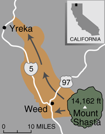
For some reason I cannot insert the picture itself but the map is poorly constructed. It has no title so right away there is no clue as to what it is trying to show. It is obviously of the Mount Shasta area, but has a strange color scheme going on, but no legend to tell the reader what it is showing. It shows two major roads, but again, unless you are familiar with the area you would have no idea. The map has two towns labeled, but no point to represent where they are so it is vague. The balance, placement and color of everything seems alright, but with no legend, it all has no meaning. The "bad map" also has some random arrows, again that have no meaning. There is no north arrow, and there is a scale. The problem with the scale though is that it has no numbers on it so therefore it is useless. This map did not have to be so poorly done. If the missing or poorly done aspects were corrected this might be an OK map. The bottom line is that now, in this context it is meaningless. It resembles little more than a map one might draw on a napkin in a restaurant. (http://pubs.usgs.gov/fs/fs002-97/images/Shastamap.gif)
The next map I would like to offer in comparison is a good, or better map showing recent earthquakes in California and Nevada. This is clearly what this map is showing because it is clearly stated in the title along with the contributing institutions. There is a scale and a legend and the colors used are easy to view and distinguish from one and other. The only problem I can really pick at here is the fact that the map contains earthquakes from the last hour, day, and week and there are some places where you cannot totally distinguish a point. It may be beneficial for this data to have a map for each one of these data sets. The size of the symbol for each earthquake shows approximate magnitude which is also distinguished in the legend. Perhaps the best aspect of this map is the fact that if you connect to it via the Internet, it is interactive. Not highly interactive but it does allow the user to select a point and it will zoom in and give you any additional/available information about the quake. If nothing else it zooms in and shows nearby towns and roads so one can get a better sense of where these quakes are. It is not the best map or the most intricate but it conveys its information in a cohesive way and is updated daily so its information is always current. ( http://pasadena.wr.usgs.gov/recenteqs/)
Subscribe to:
Comments (Atom)